
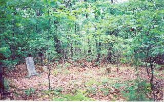
Pleasant Hill Cemetery
Medon, Madison County, Tennessee, USA – *No GPS coordinates
About
-
No location information available
Add Location - Cemetery ID:
Members have Contributed
- 21 Memorials
- 14% photographed
- No location information available Add Location
Photos
No additional photos.
Add PhotosI, Roger C. Strain, visited the PLEASANT HILL CEMETERY in June of 2002. The land was previously owned by Joe F. Cain, Deceased, but is is now owned by Ray & Jolien Harris who live at 550 Cain Rd, Pinson, TN 38366: Phone # 731-989-4567. The cemetery is between 1/2 and 1 mile north of the Harris home on Cain Rd (paved road) then about 1/2 mile east down his fence line through some very rough and grown-up taurine. The cemetery is very grown-up with trees and brush. It is 4.9 miles by road and about 3 miles, as the crow flies, from the site of the origional Cool Springs Church where Robert Granderson Rainey was converted.
I, Roger C. Strain, visited the PLEASANT HILL CEMETERY in June of 2002. The land was previously owned by Joe F. Cain, Deceased, but is is now owned by Ray & Jolien Harris who live at 550 Cain Rd, Pinson, TN 38366: Phone # 731-989-4567. The cemetery is between 1/2 and 1 mile north of the Harris home on Cain Rd (paved road) then about 1/2 mile east down his fence line through some very rough and grown-up taurine. The cemetery is very grown-up with trees and brush. It is 4.9 miles by road and about 3 miles, as the crow flies, from the site of the origional Cool Springs Church where Robert Granderson Rainey was converted.
Nearby cemeteries


- Added: 24 Feb 2007
- Find a Grave Cemetery ID: 2208001

Cemetery Photos
This is a carousel with slides. Use Next and Previous buttons to navigate, or jump to a slide with the slide dots. Use Escape keyboard button or the Close button to close the carousel.
Success
Uploading...
Waiting...
Failed
This photo was not uploaded because this cemetery already has 20 photos
This photo was not uploaded because you have already uploaded 5 photos to this cemetery
This photo was not uploaded because you have already uploaded 5 photos to this cemetery
Invalid File Type
Birth and death years unknown.
1 photo picked...
2 photos picked...
Uploading 1 Photo
Uploading 2 Photos
1 Photo Uploaded
2 Photos Uploaded
This photo is larger than 20 MB. Please resize to less than 20 MB and try again.
Too many photos have been uploaded
"Unsupported file type"
• ##count## of 0 memorials with GPS displayed. Double click on map to view more.No cemeteries found