
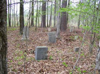
Redwine Cemetery
Woodville, Lincoln Parish, Louisiana, USA
About
-
Get directions In wooded area approx. 200 yds north of PR132
Woodville, Louisiana 71270 United StatesCoordinates: 32.45614, -92.71674 - Cemetery ID:
Members have Contributed
Photos


Redwine descendants were guides to this family plot in 1950, and at the time, the cemetery was in danger of being overgrown. The Redwine/Woodville settlement was about 10 miles south of Vienna and was home to several early families including the Redwines, Hintons, Grigsbys, Smiths, and Eilands. The Redwine family plot was enclosed at the time by a fence. Descendants reported that there was a separate burial ground slightly north of the Redwine family plot that was used to bury enslaved persons; sadly, none of those graves could be located by 1950.
This cemetery has long been abandoned and has many large trees, small saplings and underbrush growing inside. There is no fence delineating the boundaries of the cemetery, just 3 metal pipes that were driven in the ground on what apparently is the southwest, southeast and northeast corners. There is no sign marking this cemetery. It is located in a wooded area approx. 200 yards north of Lincoln Parish Road 132 (Old State Road) and approx. 0.5 miles west of the intersection of Lincoln Parish Road 132 and Lincoln Parish Road 19 (China Grove Road). There is no road accessing the cemetery, but since it is so near the parish road it can easily be walked to. To aid in locating the exact place to park alongside PR 132, I installed a small metal sign reading "RC" (see photo), which means Redwine Cemetery, on a small chinaberry tree on the north side of the road. From this sign, walk due north approx. 200 yards to reach the cemetery. There are two confederate soldier burials from the Civil War, 7 other marked graves and 20+ unmarked graves.
Redwine descendants were guides to this family plot in 1950, and at the time, the cemetery was in danger of being overgrown. The Redwine/Woodville settlement was about 10 miles south of Vienna and was home to several early families including the Redwines, Hintons, Grigsbys, Smiths, and Eilands. The Redwine family plot was enclosed at the time by a fence. Descendants reported that there was a separate burial ground slightly north of the Redwine family plot that was used to bury enslaved persons; sadly, none of those graves could be located by 1950.
This cemetery has long been abandoned and has many large trees, small saplings and underbrush growing inside. There is no fence delineating the boundaries of the cemetery, just 3 metal pipes that were driven in the ground on what apparently is the southwest, southeast and northeast corners. There is no sign marking this cemetery. It is located in a wooded area approx. 200 yards north of Lincoln Parish Road 132 (Old State Road) and approx. 0.5 miles west of the intersection of Lincoln Parish Road 132 and Lincoln Parish Road 19 (China Grove Road). There is no road accessing the cemetery, but since it is so near the parish road it can easily be walked to. To aid in locating the exact place to park alongside PR 132, I installed a small metal sign reading "RC" (see photo), which means Redwine Cemetery, on a small chinaberry tree on the north side of the road. From this sign, walk due north approx. 200 yards to reach the cemetery. There are two confederate soldier burials from the Civil War, 7 other marked graves and 20+ unmarked graves.
Nearby cemeteries


- Added: 21 Mar 2011
- Find a Grave Cemetery ID: 2393878

Cemetery Photos
This is a carousel with slides. Use Next and Previous buttons to navigate, or jump to a slide with the slide dots. Use Escape keyboard button or the Close button to close the carousel.


Success
Uploading...
Waiting...
Failed
This photo was not uploaded because this cemetery already has 20 photos
This photo was not uploaded because you have already uploaded 5 photos to this cemetery
This photo was not uploaded because you have already uploaded 5 photos to this cemetery
Invalid File Type
Birth and death years unknown.
1 photo picked...
2 photos picked...
Uploading 1 Photo
Uploading 2 Photos
1 Photo Uploaded
2 Photos Uploaded
This photo is larger than 20 MB. Please resize to less than 20 MB and try again.
Too many photos have been uploaded
"Unsupported file type"
• ##count## of 0 memorials with GPS displayed. Double click on map to view more.No cemeteries found