
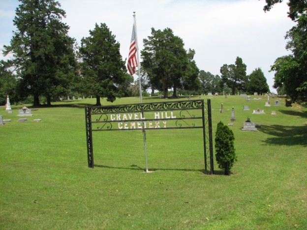
Gravel Hill Cemetery
Saint Francis, Clay County, Arkansas, USA
Gravel Hill Cemetery is located in a rural area northwest of St. Francis, Clay County, Arkansas. According to local legend, the cemetery began during the Civil War when soldiers killed in action at the nearby Chalk Bluff Battle were buried there. A portion of the "Old Military Trail," which soldiers and other travelers followed, is still visible in the section just east of Clay County Road 336. Many of the oldest graves in the cemetery are located near or at the edge of this trail. The trail was said to have been the only clear way to travel through the once surrounding swamps and dense forests.
The cemetery has around 1,092 marked graves with 661 being historic. The earliest dated headstone is 1869. The cemetery contains at least eight Civil War veterans' graves, as well as veterans' graves of other wars, including World War I, World War II, Korea and Vietnam.
Gravel Hill Cemetery is located on Clay County Road 336, approximately three and one-half miles northwest of St. Francis, Clay County, Arkansas. On November 5, 2002, it was listed in the Arkansas Register of Historic Places for its local significance as the final resting place of some of St. Francis' earliest settlers.
The cemetery encompasses approximately 20 maintained acres with three rolling hills. Gravel Hill Cemetery is comprised of seven sections of graves situated on either side of the roadway. The Hall-Gravel Hill Cemetery Association maintains the upkeep for Gravel Hill and Hall Cemeteries. The non-profit association was formed in the 1940s. The Hall-Gravel Hill Cemetery Association hosts the annual St. Francis Picnic on the third Thursday each July to raise funds. There is no charge for cemetery plots. Two caretakers oversee weekly maintenance and dig graves with a shovel as the association feels a backhoe would mar the landscape and potentially damage the headstones.
The main entrance to the cemetery is marked with a wrought iron sign and a United States flagpole. Clay County Road 336 cuts through the most western section of the cemetery. The main paved roadway follows around the southern, eastern, and western edges of the cemetery. From Clay County Road 336, one paved roadway intersects the main section of the cemetery almost in half. This roadway splits into two roadways just before connecting to the southern segment of the main paved roadway.
Gravel Hill Cemetery is dotted with large oak trees. Some of the oak trees measure several feet in diameter. Clusters of cedar trees are located throughout the cemetery. Also, trees line the cemetery around all four sides.
Most of the headstones contained religious references, including doves, renderings of the "kingdom of heaven," praying hands, and Masonic and Order of the Eastern Star emblems.
Gravel Hill Cemetery is located in a rural area northwest of St. Francis, Clay County, Arkansas. According to local legend, the cemetery began during the Civil War when soldiers killed in action at the nearby Chalk Bluff Battle were buried there. A portion of the "Old Military Trail," which soldiers and other travelers followed, is still visible in the section just east of Clay County Road 336. Many of the oldest graves in the cemetery are located near or at the edge of this trail. The trail was said to have been the only clear way to travel through the once surrounding swamps and dense forests.
The cemetery has around 1,092 marked graves with 661 being historic. The earliest dated headstone is 1869. The cemetery contains at least eight Civil War veterans' graves, as well as veterans' graves of other wars, including World War I, World War II, Korea and Vietnam.
Gravel Hill Cemetery is located on Clay County Road 336, approximately three and one-half miles northwest of St. Francis, Clay County, Arkansas. On November 5, 2002, it was listed in the Arkansas Register of Historic Places for its local significance as the final resting place of some of St. Francis' earliest settlers.
The cemetery encompasses approximately 20 maintained acres with three rolling hills. Gravel Hill Cemetery is comprised of seven sections of graves situated on either side of the roadway. The Hall-Gravel Hill Cemetery Association maintains the upkeep for Gravel Hill and Hall Cemeteries. The non-profit association was formed in the 1940s. The Hall-Gravel Hill Cemetery Association hosts the annual St. Francis Picnic on the third Thursday each July to raise funds. There is no charge for cemetery plots. Two caretakers oversee weekly maintenance and dig graves with a shovel as the association feels a backhoe would mar the landscape and potentially damage the headstones.
The main entrance to the cemetery is marked with a wrought iron sign and a United States flagpole. Clay County Road 336 cuts through the most western section of the cemetery. The main paved roadway follows around the southern, eastern, and western edges of the cemetery. From Clay County Road 336, one paved roadway intersects the main section of the cemetery almost in half. This roadway splits into two roadways just before connecting to the southern segment of the main paved roadway.
Gravel Hill Cemetery is dotted with large oak trees. Some of the oak trees measure several feet in diameter. Clusters of cedar trees are located throughout the cemetery. Also, trees line the cemetery around all four sides.
Most of the headstones contained religious references, including doves, renderings of the "kingdom of heaven," praying hands, and Masonic and Order of the Eastern Star emblems.
Nearby cemeteries


- Added: 1 Jan 2000
- Find a Grave Cemetery ID: 54083

Cemetery Photos
This is a carousel with slides. Use Next and Previous buttons to navigate, or jump to a slide with the slide dots. Use Escape keyboard button or the Close button to close the carousel.
Success
Uploading...
Waiting...
Failed
This photo was not uploaded because this cemetery already has 20 photos
This photo was not uploaded because you have already uploaded 5 photos to this cemetery
This photo was not uploaded because you have already uploaded 5 photos to this cemetery
Invalid File Type
Birth and death years unknown.
1 photo picked...
2 photos picked...
Uploading 1 Photo
Uploading 2 Photos
1 Photo Uploaded
2 Photos Uploaded
This photo is larger than 20 MB. Please resize to less than 20 MB and try again.
Too many photos have been uploaded
"Unsupported file type"
• ##count## of 0 memorials with GPS displayed. Double click on map to view more.No cemeteries found